

The Importance of Mapping and Geodesign in Architecture and Landscape Architecture
The Importance of Mapping and Geodesign in Architecture and Landscape Architecture
In the contemporary realms of architecture and landscape architecture, mapping and geodesign have emerged as transformative tools that redefine how designers approach their work. These methodologies provide invaluable insights into spatial relationships, user interactions, and environmental contexts, ultimately enhancing the quality and efficacy of design solutions.
Mapping: A Tool for Discovery
At its core, mapping is more than a technical representation of space; it is a powerful medium for discovery and understanding. Architects and landscape architects use mapping to visualize complex data sets—such as topography, land use, and social dynamics—allowing them to comprehend the intricate relationships that define a site.
Effective mapping serves as a foundation for informed decision-making. By layering various forms of information—like environmental conditions, historical context, and demographic trends—designers can uncover hidden opportunities and constraints within a site. This comprehensive view enables a more thoughtful and strategic approach to design, ensuring that projects are contextually relevant and responsive to their surroundings.
For example, when designing a public park, mapping can reveal existing pathways, natural features, and community needs. This information allows designers to create spaces that encourage social interaction, integrate natural elements, and enhance the overall user experience. In urban environments, mapping can help identify areas for potential revitalization or adaptive reuse, fostering a deeper connection between the built environment and the community it serves.
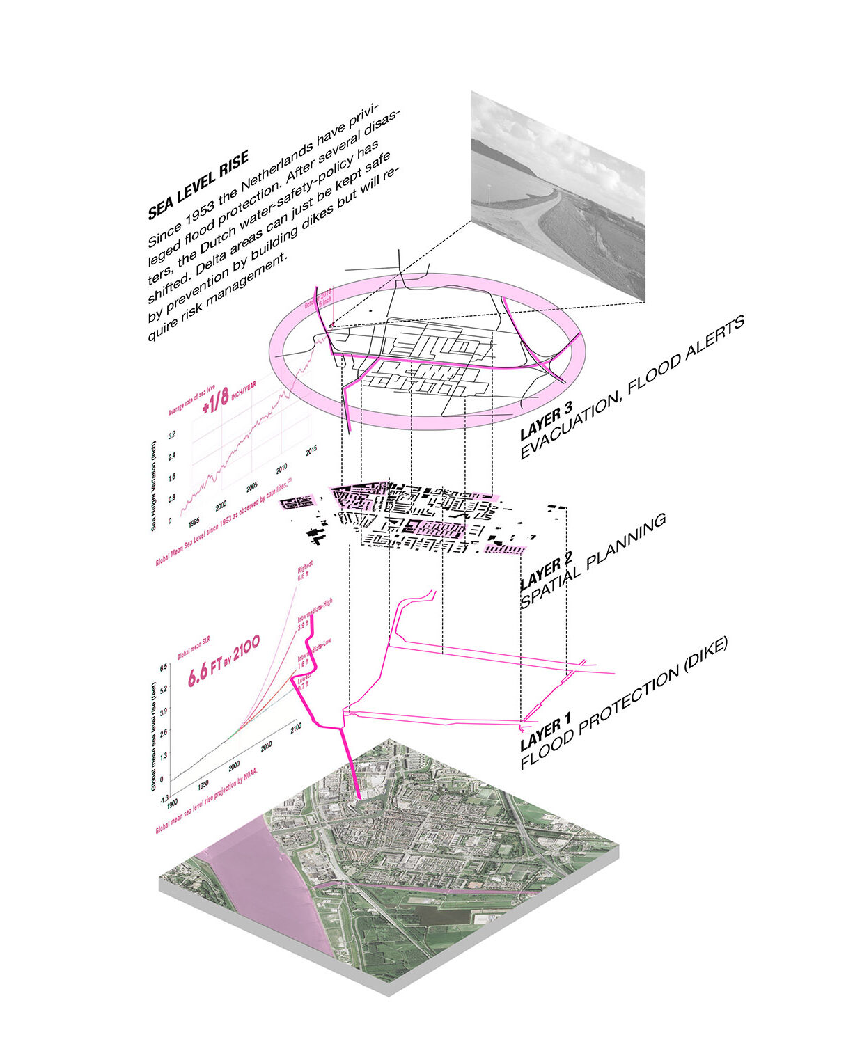
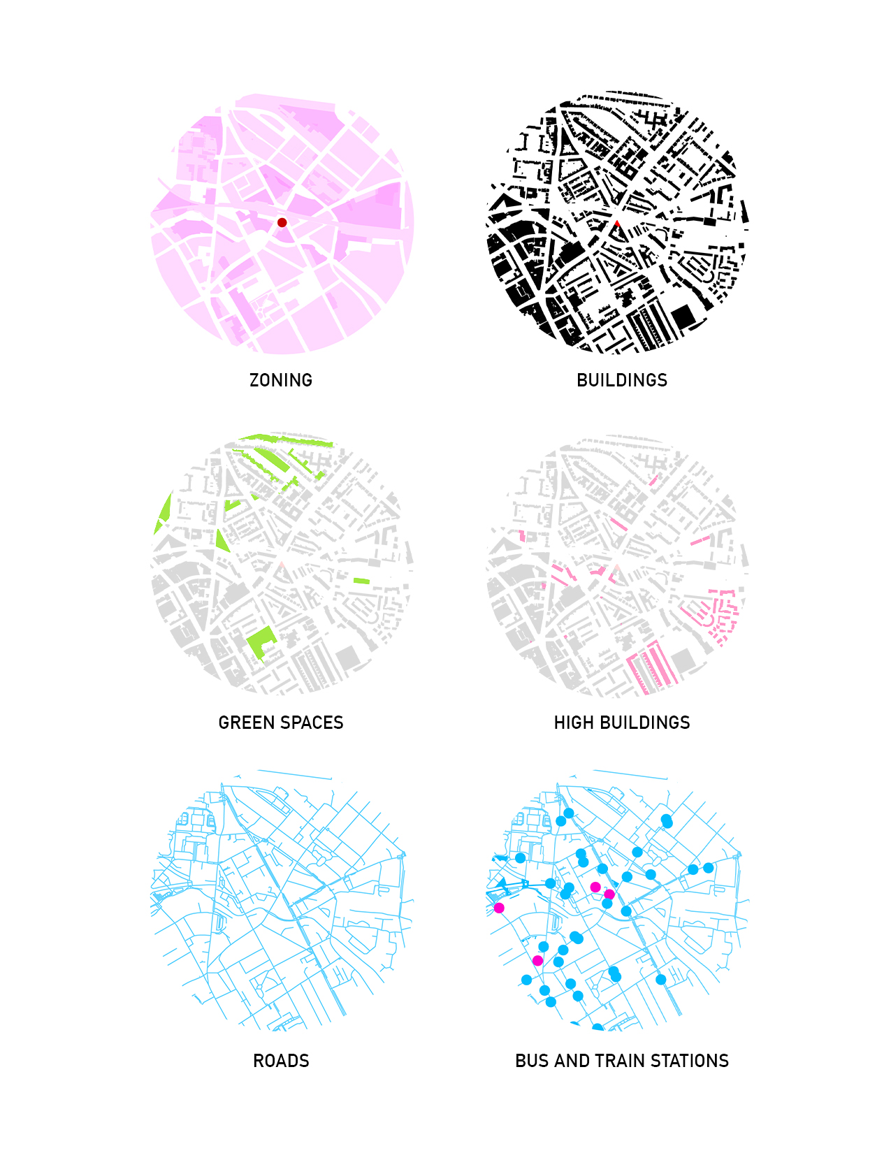
image credit: LandSpace Architecture
Geodesign: Bridging Design and Analysis
Geodesign takes mapping a step further by integrating spatial design with scientific analysis and stakeholder input. This approach allows architects and landscape architects to create solutions that are not only aesthetically pleasing but also functionally sound and socially inclusive.
By employing geodesign principles, designers can engage in a collaborative, iterative process that brings together various stakeholders—from community members to environmental experts. This multi-disciplinary approach ensures that diverse perspectives are considered throughout the design process, leading to more equitable and effective outcomes.
Geodesign facilitates real-time analysis of design proposals, enabling architects to assess the potential impacts of their decisions on factors such as accessibility, usability, and environmental performance. For instance, when planning a mixed-use development, geodesign tools can help visualize how different design configurations affect traffic flow, sunlight exposure, and user accessibility. This level of analysis allows for informed adjustments, resulting in designs that better meet the needs of the community.
Enhancing Creativity and Innovation
One of the most significant benefits of incorporating mapping and geodesign into architectural and landscape design is the enhancement of creativity and innovation. By providing a robust framework for exploration, these tools encourage designers to think outside the box and experiment with new ideas.
Mapping can reveal unconventional design possibilities—such as the potential for integrating natural water features or community gardens into urban spaces. Geodesign encourages designers to prototype various scenarios, allowing them to visualize the outcomes of different approaches and select the most effective solutions. This iterative process fosters a culture of innovation, leading to unique and impactful design solutions that resonate with users.
Moreover, the ability to visualize data and design concepts in real-time empowers architects and landscape architects to communicate their ideas more effectively. Engaging visuals help stakeholders grasp complex information quickly, facilitating productive discussions and garnering support for design proposals.
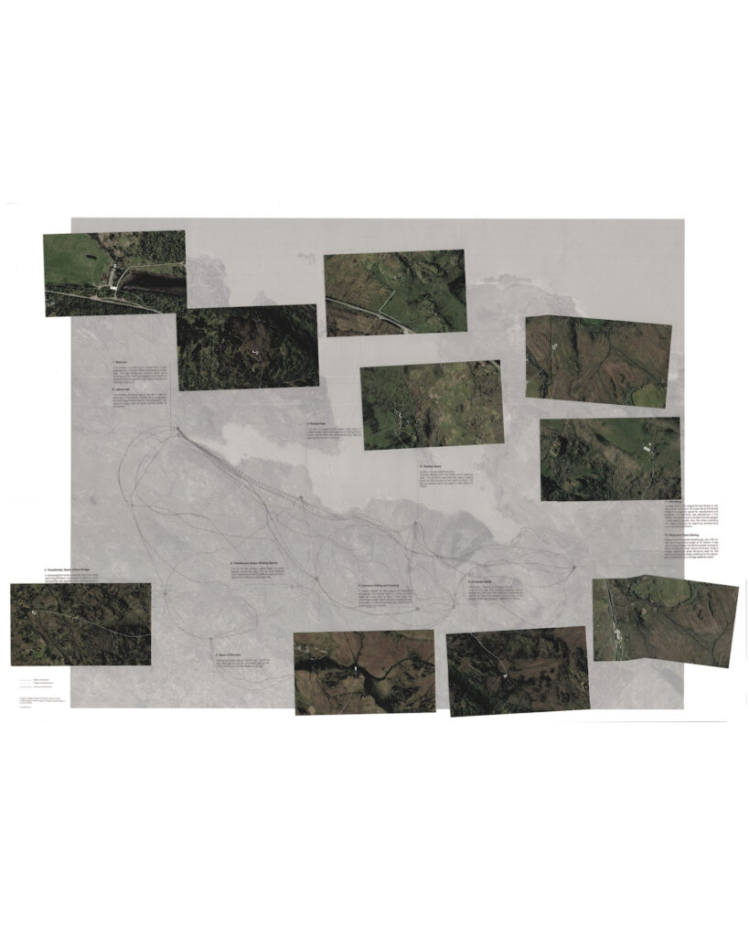
Image credit: AA School Inter7, Motion After Land, 23-24, Instructors: Marko Milovanovic and Fearghus Raftery, Student: Agnese Pazzi
As architecture and landscape architecture continue to evolve, the importance of mapping and geodesign cannot be overstated. These methodologies empower designers to create informed, context-sensitive, and innovative solutions that enhance the built environment and enrich the lives of users. By embracing mapping and geodesign, architects and landscape architects can elevate their practice, bridging the gap between creativity and analysis, and ultimately shaping spaces that are both functional and meaningful.
Leave a Reply